
This is yet another unactivated summit that I have left until now--mostly because I knew it was going to be tough. There's not an easy approach. I have scouted it a couple of times and finally felt ready to tackle it. From my last troubles with the QCX Mini on 40m, I did some testing at home and all was well, but not so much when on the summit. Focus on using the UMPP-1 key (from GM0EUL).
In the area:

There is a wide trail (used to be an ATV trail at some point) up through the lower portion to get to the base. Once at the base though, there is no trail. It is rocky with lots of dead trees, bush and desert plants among the few trees and lots of scrub oak. It was about 1,400' vertical feet, while not a lot for a mountain, it is in the upper end of hikes that I normally take. That combined with the roughness, steepness of the hike, made it a challenge. As I tend to do, I had the general route that I wanted to follow in mind, but I also break it down piece by piece as I proceed, and even step by step to make sure I'm careful and safe on the way up (and down, which is very often more challenging and risky). I had the choice of more rocky and steep, or a little more gentle but bushwhacky. I took the rocky and steep route up, and the other on the way down. If I were to ever do it again (which I won't), I think I would do the same again.

On the air:
I used my 20m dipole with 40m "extenders" made of 30 gauge wire for the antenna this time. The full 30 gauge linked dipole works well, but it's a pain since it acts a lot like fishing line and can easily get twisted and tangled. The same happened with the extenders I made. Today was the 10-point madness in AZ (activators there go to 10-point summits and get lots of high point summit-to-summit contacts), so lots everywhere want to get in on the action as well.
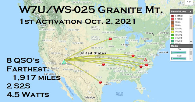
Because of that, I planned on starting on 40m to get them and then go to 20m for farther parts of the  US. Once I finally got setup and took a few pictures, I was at the time I had put in my alert (15:30 UTC or 9:30am local time). My 40m radio had the exact problems as before. I would start to send, then just beep, then nothing at all. Very frustrating! I worked great at home. I tried a few things, and couldn't get it. I missed a summit-to-summit while messing with it. I started getting worried I wasn't going to activate, so I moved to the 20m radio, changed the antenna for 20m and got on. Luckily in just a couple of minutes I had the summit activated and even got two summit-to-summit contacts (Georgia and Virginia). I got as far as North Carolina.
After getting eight contacts and then no answer to my CQ, I moved back to 40m and decided to chase to go to those on summits. Even if I had to do it by straight key, at least I would get contacts. I saw George, KX0R, a regular, was on summit. I gave him a call, he replied and gave me a 579. As I was answering, the keying stopped again. One thought was to unplug and replug and at least send a report. I did that, but didn't noticed the frequency reset. So I was able to send the report before it stopped again, but I wasn't on the right frequency so he didn't get it. Annoyed, ticked off, I decided to just take the activation as is and leave it at that. I knew it was going to take a long time to get back down and the sun was up and getting warm. I did a bit more video/picture taking, ate a granola bar, and carefully worked my way back down the mountain. As mentioned, I took the brushy route instead of the steep one. Good idea for going down. It took a while, and I was getting hot, but I made it safely and saw the pickup. Tough!
Date:02/10/2021 | Summit:W7U/WS-025 (Granite Mountain) | Call Used:AC0PR | Points: 4 | Bonus: 0 |
| Time | Callsign | Band | Mode | Notes |
|---|---|---|---|---|
| 15:37 | W9VNE | 14MHz | CW | |
| 15:37 | WA5OBV | 14MHz | CW | |
| 15:38 | N4EX | 14MHz | CW | |
| 15:38 | NJ0Q | 14MHz | CW | |
| 15:39 | W5GDW | 14MHz | CW | |
| 15:40 | N1RBD | 14MHz | CW | S2S W4G/HC-005 |
| 15:42 | AC1Z | 14MHz | CW | S2S W4V/BR-009 |
| 15:43 | AC7P | 14MHz | CW |
Black case (modified)
QRP Labs QCX Mini (20m and 40m)
20/40m dipole, homebrewed
Fishing pole mast
Earbuds
Other gear:
Leypin selfie stick tripod (for recording video)
Clipboard with magnetic strip
Android MotoZ (US topo map app, spotting, UTC time, recording)
Misc. items (for repair, food, water, etc.)
Thanks for reading!
72,
Mike ACØPR


No comments:
Post a Comment